Katherine Faull, Moravian University
American Association of Church History Annual Meeting, Chicago 2026
This week, members of the leadership team of the Institute for Moravian History and World Heritage presented a panel on “Moravians and Place” at the annual meeting of the American Association of Church History in Chicago. The panel was organized by Josh Follweiler, current PhD candidate at Princeton University and most recently Associate Pastor at Central Moravian Church, Bethlehem. Panelists were myself, Paul Peucker and Josh, and the chair and respondent was Craig Atwood. The papers provided a fascinating examination of how Moravians in the 18th and 19th century thought about place, whether as town planners, missionaries, or ministers. The specific places that were examined were Herrnhaag in the Wetterau, near Frankfurt in Germany; the early mission place of Shamokin, at the forks of the Susquehanna; and planned Moravian town congregations in Pennsylvania.
In my presentation, I focussed on the recently published Shamokin Diaries, analyzing the language of the text to build visual models of relationships between people, place and emotion. These visualizations allow us to explore the change in sentiment related to specific places (the river and the smithy) and people over the period the Moravian missionaries were working at the confluence. I reproduce these visualizations and the talk here.
The River as Metaphor and Reality
In 1747, as the Moravian missionary Johannes Hagen was returning up the Susquehanna from a trip to the grist mill at Quittapahilla, he described the river as “no different to look at than a town full of houses, the rocks lie in the water and the water flows criss-cross between them [like a warp and weft]”. Five years earlier, Count Nikolaus von Zinzendorf on his way to the forks of the Susquehanna at Shamokin, Pennsylvania had also described the river in lyrical terms, the “water [was] beautifully transparent, and were it not for smooth rocks in its bed, it would be easily fordable. In crossing, we had therefore to pull up our horses and keep a tight rein.” I begin this investigation of the notion of a sacred confluence with these two quotations from Moravians to set the scene, literally and figuratively, for trying to understand how this group, which in the 18th century was spread across the globe from Greenland to the Caribbean, and from Kazan in Central Asia to Pennsylvania, understood the power of place. For them, did landscapes play a role in the choice of mission in a way that was not only defined by utility and strategic advantage? Did landscapes themselves hold sacred value? And if so, how did this concept differentiate itself from indigenous concepts of sacred landscapes?
Methodology
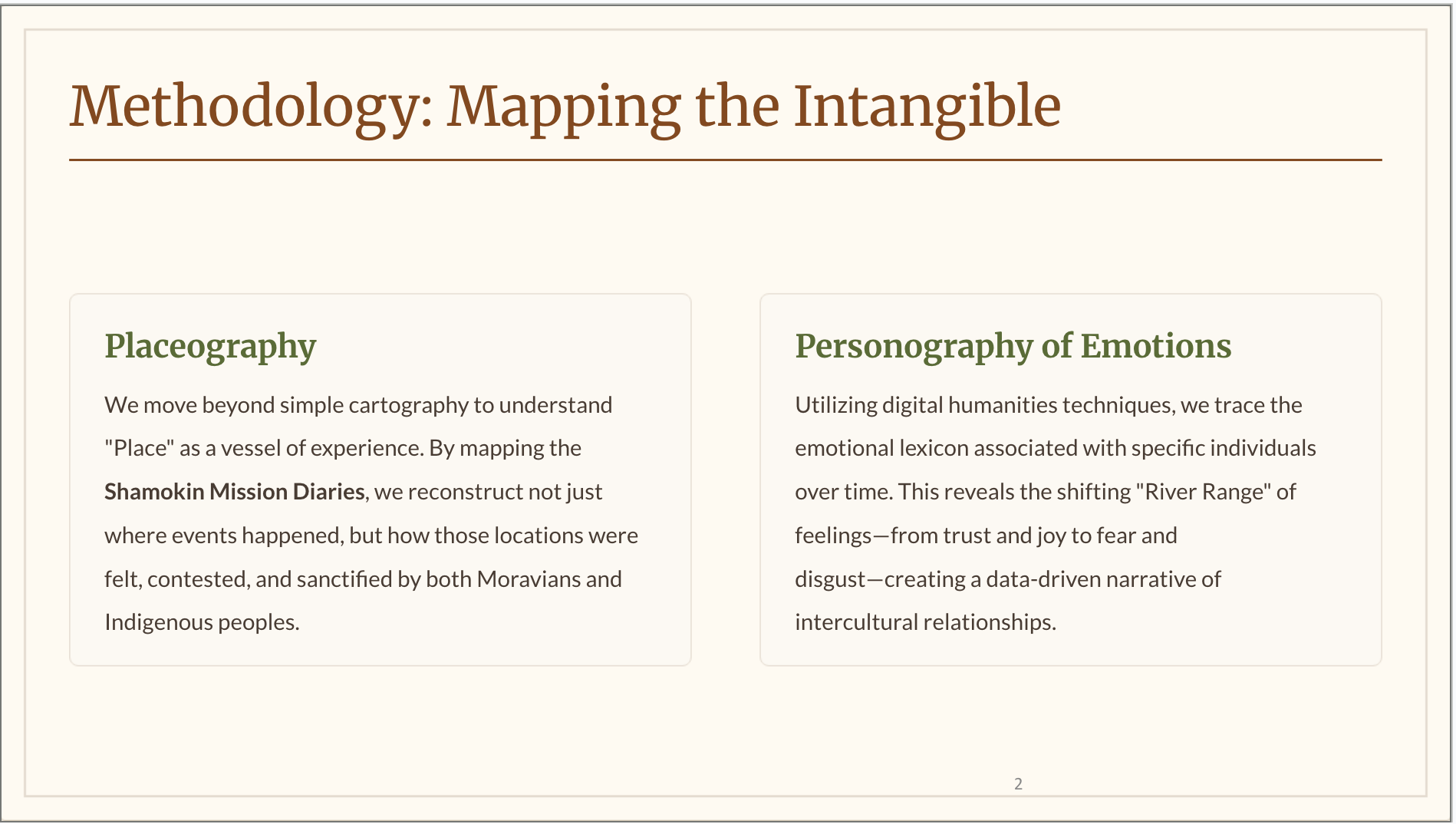
The River as Metaphor and Reality
In order to address these questions, I have turned to the language of the Shamokin diary. As a philologist, I work with words. As a digital humanist, I use that language as data to recognize patterns and visualize them. As a translator, I know well that translation is ‘the most intimate act of reading’ (Gayatri Spivak). So, with these tools, while transcribing and translating the Moravian mission diaries from Shamokin, Pennsylvania, I was struck by how the mission diarists described the landscape around the confluence (river, islands, bluffs, riffles, riparian buffers) as central to understanding their role. The physical geography of Shamokin constituted a confluence that required constant negotiation, with the forces of nature made manifest in floods and snowstorms, late frosts that destroyed newly planted crops, storms, and even an earthquake. This place shaped a unique mission encounter in which Moravians operated under the Indigenous authority of the Haudenosaunee. This adaptive mission strategy, centred on work rather than worship as primary witness, contrasts sharply with later Moravian missions on the North Branch of the Susquehanna (1765-1772), where mission places were built as intentional communities of worship and work and reveals how place determined religious praxis in colonial contact zones.
This paper explores the relationship between emotion, agency, and topography that emerged at Shamokin through the Moravian mission presence from 1742 to 1755, in the critical years preceding the French and Indian War. Drawing on the recently translated and published mission diaries (Faull, 2024), I examine how Shamokin differed from other Moravian settlements in colonial America. Unlike Bethlehem or Gnadenhütten, which were established as intentional communities, Shamokin existed as what Count Zinzendorf recognized as a spiritually strategic location where Moravians operated under explicitly negotiated Indigenous constraints (Merritt, 2003; Pointer, 2020).
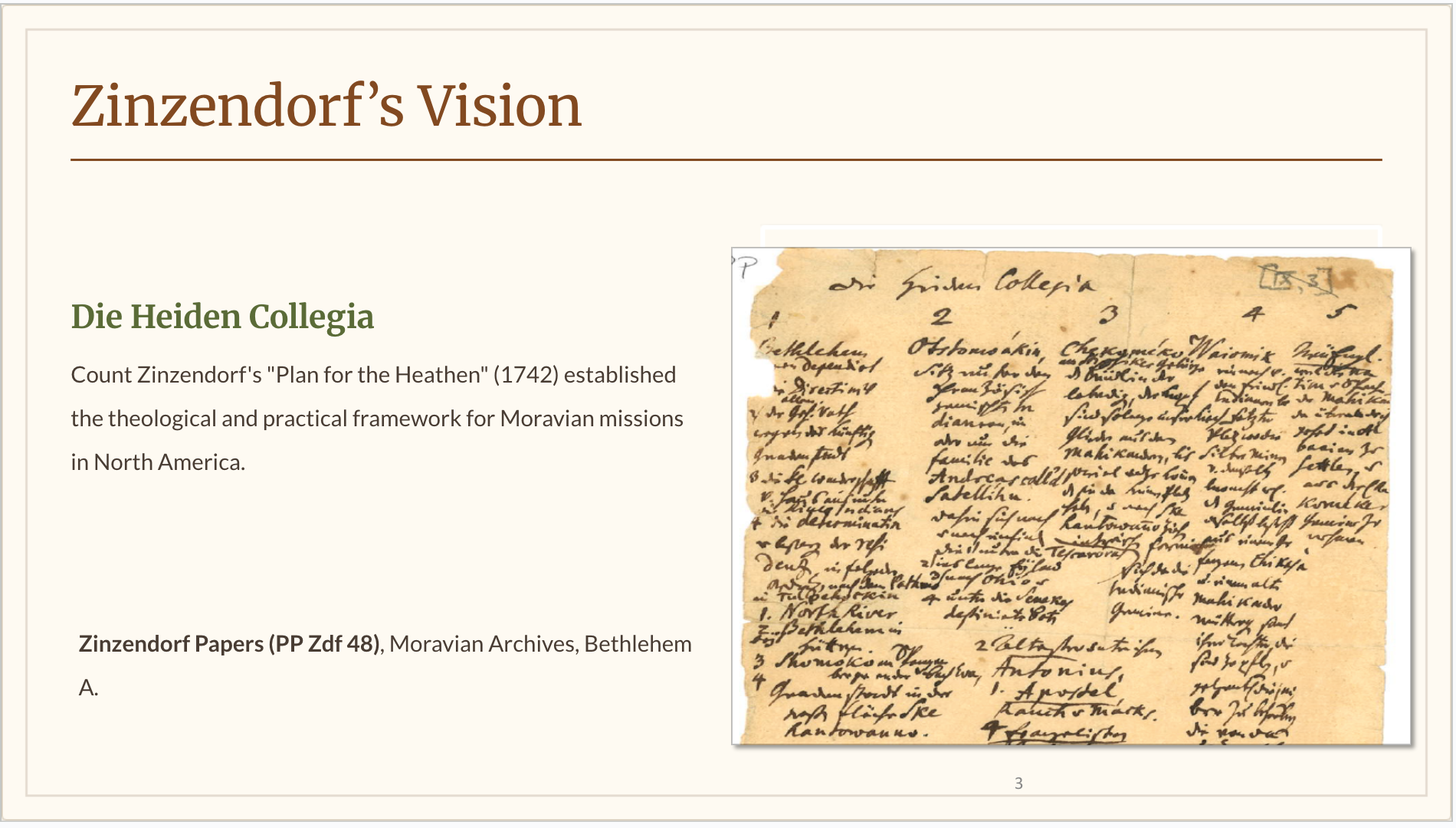
The Moravian presence at Shamokin represented a central part of Zinzendorf’s mission plan for North America, which emphasized strategically practised humility and cultural respect (Atwood, 2004). I will show how this humility and respect was manifested in the mission through the lens of indigenous agency. The physical place directly influenced religious practice, with European hymns sung alongside sweat lodge ceremonies, pastoral visits conducted across the frequently swirling, ice-filled river, and Shikellamy, the Oneida sachem with oversight over Shamokin, finding spiritual and physical refuge in the Moravian loghouse while maintaining Indigenous practices. Through the 1747 formal agreements establishing a blacksmith’s shop, the Moravians created a shared sacred space where work itself became a form of witness.

Building on the work of Jane Merritt, Richard Pointer and Rachel Wheeler that challenge the older historiographical view of Shamokin, where Shamokin was described as a “place of the prince of darkness”, the Moravian mission diarists describe a place of challenge, both physical and spiritual, but also of cultural and spiritual exchange. Similarly, Rachel Wheeler describes Mohican Christianity in New England, which she argues represented an intentional spiritual choice that transformed both Native and non-Native spirituality, claiming that the Moravians succeeded where Congregationalists failed partly because they were “culturally non-aggressive” colonial outsiders who lacked expansionist ambitions. This approach enabled genuine mutual learning and spiritual exchange between missionaries and Native peoples. In his recent study of Moravian theology on the margins, Ben Pietrenka claims that these liminal spaces radically upturned hierarchies of power. Indeed, such ruptures have been described by Katherine Gerbner in her new book “Archival Irruptions” as subversive discourses of power that are documented in the archives and require a radical counterreading of the traditional narratives of mission, race, and colonialization. It is against this backdrop that I investigate today the relations of agency and religion in the marginal place of Shamokin, Pa.
The town of Shamokin had long functioned as a crucial hub in a vast network of Indigenous mobility. The Moravian mission diaries of the 1740s and 50s reveal a constant movement of Indigenous peoples up and down the Susquehanna River: Tuscaroras, Cayugas, Oneidas, Mohawks, Nanticokes, and Lenape peoples are constantly arriving, departing, hunting, and passing through. Thus, Shamokin was not a static settlement but a dynamic crossroads where multiple Native nations intersected with European traders, missionaries, and colonial officials.
The Moravians’ attitude towards Shamokin evolved through contradictory emotions that traced the broader tragedy of Indigenous dispossession in the Susquehanna Valley. Initially, Zinzendorf well understood the importance of the forks of the Susquehanna as a strategic touchpoint with the powerful Haudensaunee Confederacy and its spiritual possibility—a place where their message of salvation could be spread, where communion could be celebrated, where the gospel might take root among multiple Native nations gathered together. Yet this hope coexisted with frustration over a place that never quite became what they envisioned, where missionary efforts yielded limited lasting results, and safety couldn’t be guaranteed.
Shamokin served practical (if ethically challenging) purposes: a place to develop a relationship of trust with the Haudenosaunee, through building a blacksmith’s shop for gun repairs for Indigenous peoples. The diary is replete with references to a working landscape where Indigenous economies intersected with colonial trade networks, though increasingly on terms dictated by land sales and territorial encroachment. Whereas previous European visitors, such as John Bartram on his visit in 1743, described the place of Shamokin as ideal land for settlement, with its “peach trees, plums, excellent grapes,” and also described the Indigenous people of the area as unable to cultivate it for themselves, the Moravians saw the Indigenous population as politically sophisticated, technologically capable, and spiritually discerning, understanding and respecting their reasons for not cultivating the land according to colonial rules as being rooted in resistance to colonization.

The mission diaries reveal the dark reality of such colonial encroachment, evidenced primarily through the chaos of violence and disorder fuelled by alcohol. The diarists record regular drinking & carousing” (9/17/1745), “all night dancing & howling” (11/2/1745) where “Everybody [is] drunk” (6/5/1748, 6/9/1748) with “drunken brawls & fighting” (2/24/1749) causing “Sleepless night for missionaries” (1/11/1749) and culminating in the Penns Creek “Massacre of white neighbors” (10/16/1755) by the Western Delaware who were allied with the French.
The Moravian missionaries at Shamokin thus lived a paradox of witness and persistence amid overwhelming chaos. Between 1747 and 1755, they engaged in relentless physical labor—constructing two mission houses, laying floors, building chimneys, repairing bridges, and erecting a smithy that became central to their relationship with the Indigenous community. Their documentation of measurements, dates, and improvements suggests both immense commitment to their work and an attempt to create order in an environment beyond their control.
The forge operated as more than a blacksmith shop—it was a tool of engagement and a testament to pragmatic adaptation. The missionaries fixed guns, made charcoal, accepted payment in hides and pelts, and deliberately kept cultivation “at the level of the Indigenous economy” rather than imposing European agricultural models. Yet their economy remained perpetually precarious: starvation diets, crops ruined by frost and hail, with chickens and horses stolen or lost.

Yet amid this distress, the Moravians maintained remarkably disciplined spiritual practice. They held communion services, foot-washing ceremonies, and, in the 1750s, lovefeasts requiring sugar and tea, Easter dawn services at the turnip field where Brother Hagen had been buried, and services that ran until 2 a.m. The stark contrast is captured in Christmas observed with lovefeast while chaos reigned outside. Their principled Sabbath observance—refusing to let Indians demand that they work at the forge on those days—led to “astonishing questions” even as it was criticized for interfering with economic needs. One poignant detail reveals both their vulnerability and their peaceful intervention: a brawl “silenced by missionary’s singing.”
By 1755, the mission’s fragile stability collapsed. Advised to flee (advice “disregarded”), threatened with land claims, facing “bloody action by hostile Indians,” they finally witnessed the “massacre of white neighbors” in October. The mission house and forge were offered for sale with no date given—a poignant detail suggesting the uncertainty of when they could actually leave.
The archival evidence clearly shows that the Moravians at Shamokin operated within Indigenous political and cultural frameworks, adapting themselves to Native authority, while simultaneously navigating colonial politics. When Shikellamy held a Nanticoke Council in 1747 to address the issue of two Nanticokes who had been shot with arrows, the Moravians participated by preparing food “which they placed before the council”—thus serving the Indigenous political process rather than directing it. Significantly, when the Nanticokes showed reluctance to listen to Shikellamy, the Moravians attributed this to “not to some essential notion of their race but rather to them being surrounded by traders,” placing blame on colonial disruption rather than on any inferred Indigenous characteristic.
Cultural exchange flowed in multiple directions. In 1757, Moravian visitors to a Shawnee village on the North Branch were invited to a sweat lodge and accepted, afterwards enjoying an evening concert of European chorales and music for strings played on violins provided by the Indians—a remarkable scene of reciprocal hospitality and shared musicality. Medical practices also bridged cultures: on July 10, 1747, several Indians came to Brother Hagen to be bled, reflecting a shared humoral worldview where both Moravian and Indigenous medicine understood the body as a system of flows requiring balance.
Yet the missionaries also practised strategic isolation, maintaining strict “aloofness from traders” who were “strictly kept out of the house.” This wasn’t cultural superiority but a survival strategy in an environment where traders brought the twin scourges of alcohol and violence. The Moravians navigated a careful path: adapting to Indigenous authority and participating in Native cultural life while protecting their mission space from the destabilizing forces of the colonial economy. Their approach recognized that the greatest threats to peaceful coexistence came not from Indigenous peoples but from European traders whose liquor traffic undermined the very communities the Moravians sought to serve.
The smithy at Shamokin was clearly the economic and relational heart of the mission. The Moravians structured its operation to align with Indigenous economic patterns rather than imposing European models. Indians were “kept on the preferred list,” receiving priority service, while payment came in hides and pelts through immediate exchange, avoiding the debt relationships that characterised exploitative trader practices. The forge offered practical services: repairing guns, manufacturing charcoal, and meeting community needs on a self-supporting basis. This economic philosophy extended to their agricultural practices: they explicitly kept “farming activities on the level of Indian economy” and maintained “agricultural enterprises at a minimum.” Rather than establishing a European-style plantation that would signal territorial claims and economic dominance, the Moravians adapted to Indigenous economic patterns, using the smithy as a tool of engagement that served the community without attempting to transform it.
On August 2, 1747, letters from Bethlehem arrived (always a source of joy), but this time with the critical news that agreement had been reached with the Colonial government to build the smithy. Shikellamy calls a council of the Indigenous leaders, which permits Bishop Spangenberg to speak through his letters, composed in Onondaga and signed with his Haudenosaunee name, T’girhitonti. That same evening, the Moravians celebrated their first communion, thus demonstrating that work and sacred life were intertwined. Hagen writes in the diary, “How we felt at this communion with our Lord I cannot describe. It was also important to us because it is the first one here in the wilderness, perhaps as long as the forest has stood.”
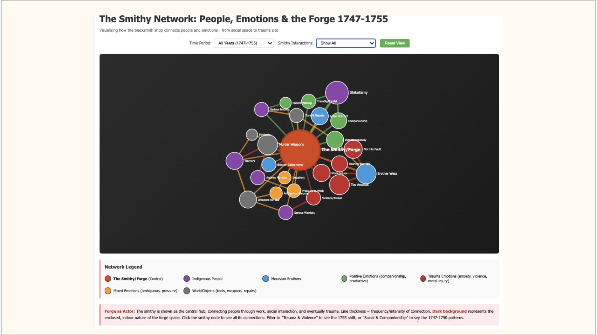
But the smithy was much more than a place of work- it was central to the Moravians’ mission at Shamokin, constructed and operated by them. In this interior space, they controlled who could enter and when, and who could have work done and when. According to the agreement with Shikellamy, it was Indigenous agency that decided whether the warriors needed to pay for the work. The space of the smithy, also, demanded a moral position in which the Moravians could not avoid complicity in the repair of arms. Every decision they made demanded a moral choice and left them no space for passivity in the face of conflict.
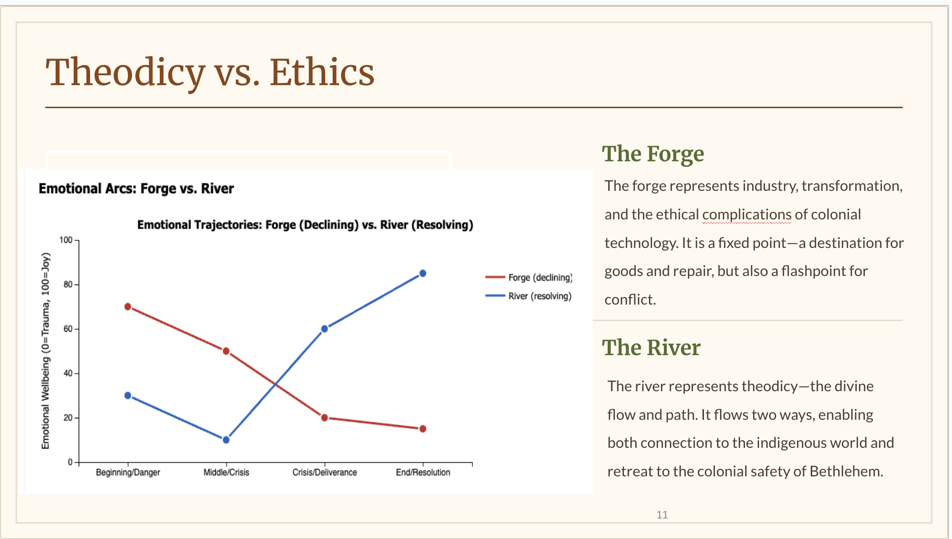
Looking at the smithy as a fulcrum of emotion and agency, we can view this diagram which us designed to show emotions connected to the smithy over time. For example, if one wants to talk of an emotional register, the smithy in 1755 is a place of impossible choices for Brother Wesa. A place that had once been a space of Shikellamy’s companionship (1747-8) had become a site of trauma (1755) where Wesa is forced to repair the bloodstained weapons of war.

If we perform the same analysis for the Susquehanna River, we can see that the river serves as an antidote to the ethical conflict in the smithy. It belongs to the realm of nature, an open force of nature beyond human control in a pre-existing landscape. It acts independently of human will, flooding, freezing, and flowing. Moravians respond to it but do not control it. It also offers a morally neutral territory, carrying warriors up and downstream. It offers danger through its rocks, riffles, and ice floes. Yet it is also deeply embedded in colonial geography, defining the boundaries of lawful settlement. The river has a social function, too, linking Shamokin with the Wyoming Valley (one of Zinzendorf’s original Heiden Collegia).

But not only are places linked to emotion; so are people. First, references to specific places are accompanied by specific sentiments in the diary narrative (of course, there are multiple diarists, and their reactions to people and places also determine the emotional index).
Interestingly, Bethlehem is always seen as a place of refuge, frequently referred to during this period by those on mission work as “das Kripplein,” the little manger. People are also associated with emotions: Shikellamy is always a friend and protector, and when he dies, his sons, Johan and Logan, inherit his role but are not as intimately involved in the work of the smithy.

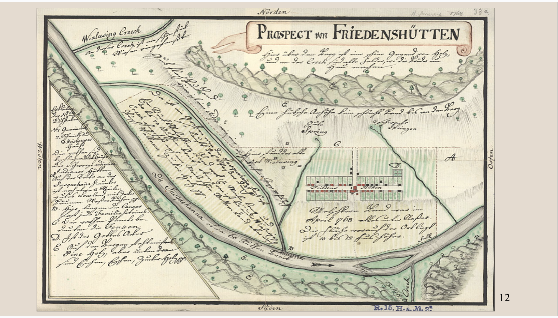
The sense of sacred place at Shamokin contrasts sharply with that of the Moravian North Branch mission sites—particularly Friedenshütten (“Huts of Peace”) (1768-1772) and Scheschquehannunk (1769-1772)—both established between Pontiac’s Rebellion and the American Revolution. These later “Places of Peace” were intentional Christian communities led by converts such as Johannes Papunhank (a Munsee religious leader baptised by David Zeisberger). Friedenshütten embodied the Moravian mission vision that had eluded Shamokin: a thriving mission town with substantial infrastructure, agricultural prosperity, and a vibrant liturgical life that earned admiration from colonial officials and Indigenous leaders alike. The community erected impressive buildings, including a meeting house with glass windows and a belfry, produced abundant harvests that fed both residents and countless visitors, and grew from fourteen to forty-seven communion participants. Their sophisticated governance structures, bilingual education, and extraordinary hospitality—extended even when it strained their own resources—demonstrated Indigenous Christian agency and strategic cultural competence. Yet this success contained its own vulnerability. Built on disputed land, caught between competing political pressures, and ultimately forced to abandon everything on May 3, 1772, Friedenshütten revealed the brutal reality that no amount of prosperity, spiritual commitment, or colonial admiration could protect Indigenous peoples from the violence of expansion and the fundamental insecurity of their land rights. Where Shamokin had struggled against chaos, Friedenshütten achieved everything the Moravians envisioned—and still could not survive.
To return to the questions with which I began this presentation: did landscape play a role in the choice of mission in a way that was not only defined by utility and strategic advantage? Did landscapes themselves hold sacred value? And if so, how did this concept differentiate itself from indigenous concepts of sacred landscapes? I would argue that landscape of Shamokin was selected strategically but became sacred though the 8 years of the mission being active there. Shamokin was selected strategically: Shikellamy’s invitation, Six Nations council site, smithy opportunity. But eight years of dwelling transformed it. The missionaries noticed the river’s beauty (“like warp and weft”), tended Brother Hagen’s grave with pre-dawn visits, called their new house “this dear little place” and composed a hymn for it. They left “not without little tear.” Thus landscape accumulated sacredness through relationship, not geography.

BETHLEHEM was a permanent sacred, always positive across all periods. Letters from there “like honey and balsam.” The place they couldn’t stop longing for.
THE RIVER: Theodicy sacred. Sacred when God acted through it – the flood became Noah’s ark, dangerous falls became deliverance sites. Natural danger without moral culpability.
SHAMOKIN: Relational sacred. Sacred through Shikellamy’s daily protection, through communion’s “unspeakable proximity.” But this sacredness evaporated when relationships fractured in 1755.
The emotional geography reveals that the sacred for the Moravians wasn’t fixed in land but in relationships and divine action. How did this understanding differ from Indigenous sacred landscapes? The Shamokin diary shows that both groups navigated the tension between place and the need to be mobile. Therefore, the relationship to place was not simply “fixed” or “portable”. For the Moravians, Christ is portable (they can worship anywhere). However, through the text we can see that their emotions showed a strong longing for Bethlehem, and when crisis arose, it forced a flight to their permanent sacred centre.
For the INDIGENOUS PEOPLES, place was vital to rituals of identity. For example, the Nanticoke reburied their departed’s bones, the islands in the river were places for council fires and decision making, the land and forest and water were places for the hunt and trade. At the same time the indigenous people demonstrate strategic mobility (seasonal migration, dispersal under pressure) and also, most importantly, exercised agency over who could stay, who had to leave Shamokin. The critical difference was that Moravians could leave because Bethlehem remained secure. Indigenous people maintained protocols through displacement because colonial violence destroyed their sacred places.
The Moravians sought a “portable sacred” – Christ present anywhere. But the emotional geography of the Shamokin diary reveals they couldn’t escape place through theology, in that they couldn’t worship safely without Indigenous protection (Shikellamy made devotion possible); they couldn’t resolve moral complicity in one place (the forge), so they fled to another (the river) where suffering could be explained theologically. And finally, they couldn’t stop longing for one specific place (Bethlehem).
Meanwhile, Indigenous people maintained sacred obligations to specific places (returning bones, ritual sites) while strategically adapting to colonial violence – demonstrating not attachment vs. mobility, but agency under impossible circumstances. Colonial violence, not theology or culture, determined who kept their sacred places. The Moravians fled to Bethlehem. Indigenous people were displaced from Shamokin. Both groups’ relationship to landscape was relational, adaptive, and vulnerable – but only one group had a secure sacred center to return to.
Therefore, landscape mattered beyond utility, but it became sacred through dwelling, not through inherent geography. Landscapes held sacred value for the Moravians – but through relationships, divine action, and community, not fixed spiritual power. This differed from Indigenous concepts – but both groups navigated place/mobility more than simple binaries suggest. The emotional geography reveals that vulnerability, not belief, shaped the sacred landscape. And, at least for a while, Indigenous agency determined who could stay.