
Yesterday I fulfilled a desire, harbored for all the years I have been working on the Susquehanna River; and that was to travel as far south as I could to the mouth of the Chesapeake Bay. It took a lot of driving and navigating, but I did it.
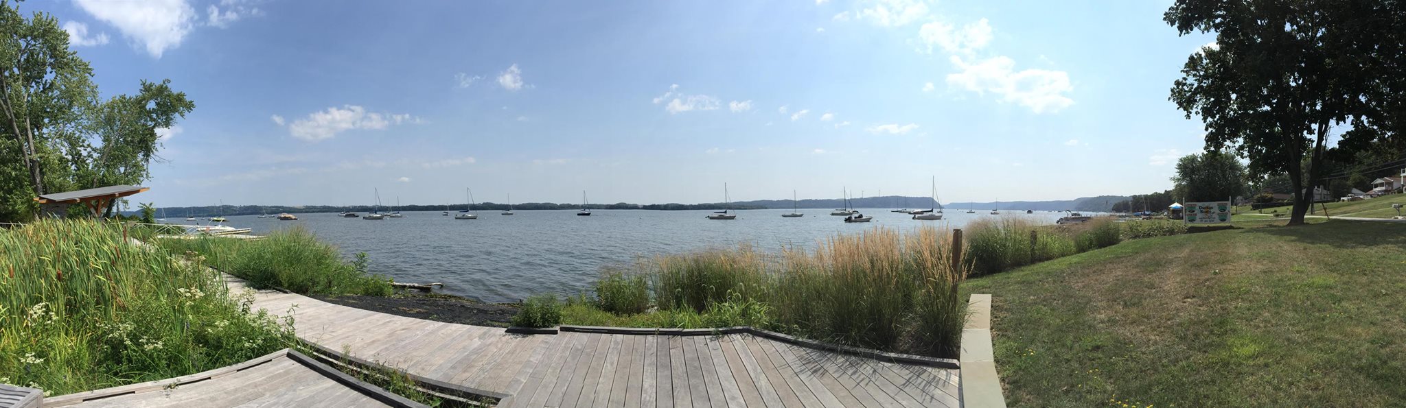
This desire was not merely a romantic wish to experience the river from source to bay (which now I have done, albeit not always in a kayak). I was stunned at the changes the river goes through, from its modest beginnings up in Cooperstown; its torments at the hands of the post-industrial towns of Binghamton and Wilkes Barre; its majesty on the North Branch as it winds its way through the mountains, steep wooded ridges rising on both sides and monitored by high soaring eagles; the calmer waters as it joins with the West Branch at Sunbury and provides the motorist on route 15 with a most glorious companion with its wide stretches, and myriad wooded, farmed, and rocky islands, that reminded one Moravian missionary of a city with its avenues and cross streets. And then finally, the transformation of a river into a series of lakes, some over 200 feet deep, formed behind the hydro-electric dams of Safe Harbor, Holtwood and Conowingo.

It is late summer and the river is low. From the main branch down to Wrightsville, the bed rock is visible, jutting up over the surface to make riffles that would please any kayaker and exposing the ledges in the river bed. The water is warm, maybe too warm for the fish to enjoy and thus the eagles hunt elsewhere. But below the last dam, at the spillway of the Conowingo, this wide full river is a trickle, meandering like an afterthought through the rocks. Its banks bustling with anglers and birders, this final stage of the river seems on an August afternoon weary of its 444 mile journey to the sea, almost succumbing to defeat at the hands of human industry. As I looked downriver all that was visible were the final metal bridges crisscrossing the viewscape before you get to the Bay. An ignominious end.
I had a very pragmatic need to make this journey yesterday. I am in the final stages of compiling a report for the National Park Service on the Indigenous Cultural Landscape of the Lower Susquehanna. As part of the segment planning process, I am heading up a team of scholars and mappers to make an argument to the NPS for certain landscapes of the Susquehanna to be designated as “evocative of the natural and cultural resources supporting American Indian lifeways and settlement patterns in the early 17th century.” (See http://www.nps.gov/chba/learn/news/indigenous-cultural-landscapes.htm) These landscapes are also important to descendant communities today, and are intended to aid conservation strategies in the Chesapeake and its watershed. This has not been an easy process. As this approach to understanding large landscapes is still in the development stage, it has not always been clear how to describe an “Indigenous Cultural Landscape” without succumbing to the romanticization of an indigenous viewpoint, without projecting the settler culture’s desire for a “edenic” past (to quote my colleague and collaborator, Alf Siewers). And indeed, the displacement and genocide of the Native populations of Pennsylvania means that those descendant people are probably radically dislocated from these landscapes. Unlike Virginia or Maryland or New Jersey, Pennsylvania is one of only two states left in the Union that does not recognize the presence of Native nations in its borders. Thus, the very notion of a Native heritage landscape is thoroughly disrupted. And unlike the PI’s in other Indigenous Cultural Landscape studies (as on the Nanticoke river) I can’t go to the recognized American Indian nations and ask, “What does this place mean to you?” because they are elsewhere.
The vast amount of work that has been completed by my colleagues and our students on the history and culture of the Susquehanna River under the umbrella of the “Stories of the Susquehanna” is crucial to the rebuilding of Native American connections to the landscapes that were left behind. Through outreach to the Haudenosaunee, facilitated by Sid Jamieson, and public history events, such as the North Branch Heritage Kayak sojourns, organized by David Buck of Endless Mountains Outfitters, bonds are being rebuilt between the landscapes of the Susquehanna and the descendants of those people who populated them, hundreds of years ago. And there are those, like Onondago Canoe Club owner, Hickory Edwards, whose mission it is to “reindigenize” the river. Paddling the length of the Susquehanna last year, down to Annapolis and then walking on to Washington DC to the opening of “Nation to Nation” exhibition of treaties at the Museum of the American Indian, Hickory might exemplify a Native view of Indigenous Cultural Landscapes. They are being rediscovered, like a newly revitalized part of the body, awakened after centuries of numbness.
The guidelines for creating an IC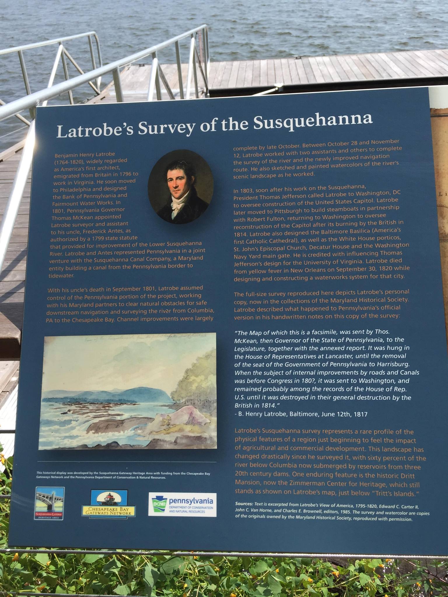 L make it clear that the importance of landscapes to descendant communities today is central. But my question is, who is the audience or viewer of the landscape? Yesterday, as I paused for a meeting at the Zimmerman Heritage Center on Long Level, I was thrilled to see the progress that had been made there in creating interpretive materials for the passing public. A stylish jetty on the waterfront has been built, shaded by a sloping roof and lined with benches wide enough to provide work space for me and my computer and my collaborators. In front of us, a full size replica of Benjamin Latrobe’s glorious survey of the Lower Susquehanna, commissioned by the Pennsylvania State legislature for the “improvement” of the river from Columbia down to the head of the Bay, is displayed, revealing a water viewscape radically different from that which confronts today’s visitors who can read, “Latrobe’s Susquehanna survey represents a rare profile of the physical features of a region just beginning to feel the impact of agricultural and commercial development.” As true as this is, the view across the river, now a lake, also points us in the direction of Washington Boro, the site of dense Native American settlement and horticulture/agriculture during the timeframe delineated by the requirements of the Indigenous Cultural Landscape initiative. Benjamin Latrobe’s survey certainly gives the viewer an idea of the radical change in the river thanks to the hydroelectric dams of 20th century energy production, but what it does not tell us is that this was a center of trade, exchange, agriculture and human interaction with the environment for hundreds of years prior to his “clearing” or dynamiting of a channel up the river. This part of the story is told behind the viewer. Turn around and climb the escarpment and you will find the “Native Lands County Park”, which at my last visit to this place was just an idea. Now the visitor can learn about the last known village of the Susquehannock Indians that stood on top of this hill (1676-1680) (the Byrd Leibhart site) where once 3,000 people lived in a stockaded four acre village in 16 ninety foot longhouses. The view from this hilltop reveals the wide sky, water and rolling hills of the Piedmont, now punctuated with wind turbines and McMansions. But the sense of this landscape is strong enough to blot out those intrusions of 21st century America (for now).
Even with the deep knowledge I have of this landscape, its history of human settlement and conflict, its soils, its elevation, its climate, its cultivation, I cannot see it through Native eyes. And I should not. If all that this initiative does is to deepen the settler culture’s understanding of the place on which it stands and builds and dynamites and dams, then I think much will have been achieved. However, within the borders of Pennsylvania’s bastion of historical denial, within this state of willed and legislated amnesia, we are a very long way from reindigenizing our landscapes.
